
Agriculture & Forestry Mapping Across Victoria
From plantation inventory and LiDAR tree surveys to farm drainage mapping, crop health assessment, and weed distribution mapping — Storm Spatial provides the spatial data that helps landowners, managers, and specialist consultants understand what’s happening on the ground.
Geelong-based and operating across regional Victoria and beyond, our team combines drone aerial surveys, LiDAR scanning, and multispectral imaging to produce accurate, practical mapping outputs tailored to your property and your project.
What We Map — and What You Receive
Storm Spatial provides mapping and spatial data services across four areas of agriculture and forestry:
Forestry Mapping
Crop, Pasture & Vegetation
Farm Terrain & Drainage
Weed & Treatment Mapping
Forestry Mapping — LiDAR Tree Survey & Plantation Inventory
LiDAR-based forestry mapping allows individual trees to be detected, measured, and documented across large areas of plantation, native forest, or mixed land — far more efficiently than ground-based methods. Storm Spatial’s forestry mapping service is designed to support plantation management, carbon project baselines, biodiversity assessments, and large-scale tree inventory programmes across Victoria.
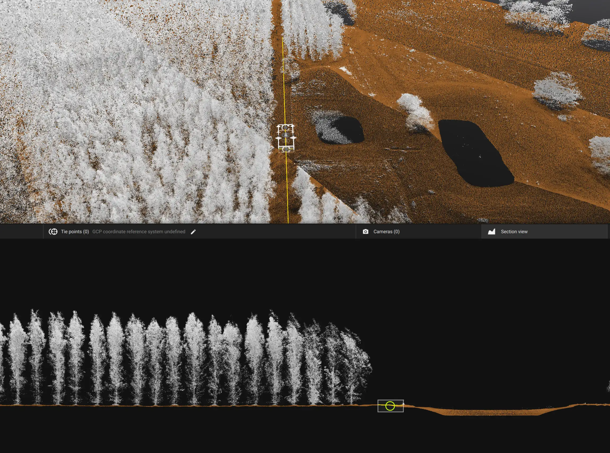
What Our Forestry Mapping Captures
Individual tree detection across the mapped area
Farm Terrain & Drainage Mapping
Understanding how water moves across your land is fundamental to drainage design, irrigation planning, and erosion management. Storm Spatial’s farm terrain mapping uses accurate, drone-captured elevation data to produce detailed terrain models that reveal drainage patterns, low areas, and waterlogging risk — across properties of any size.
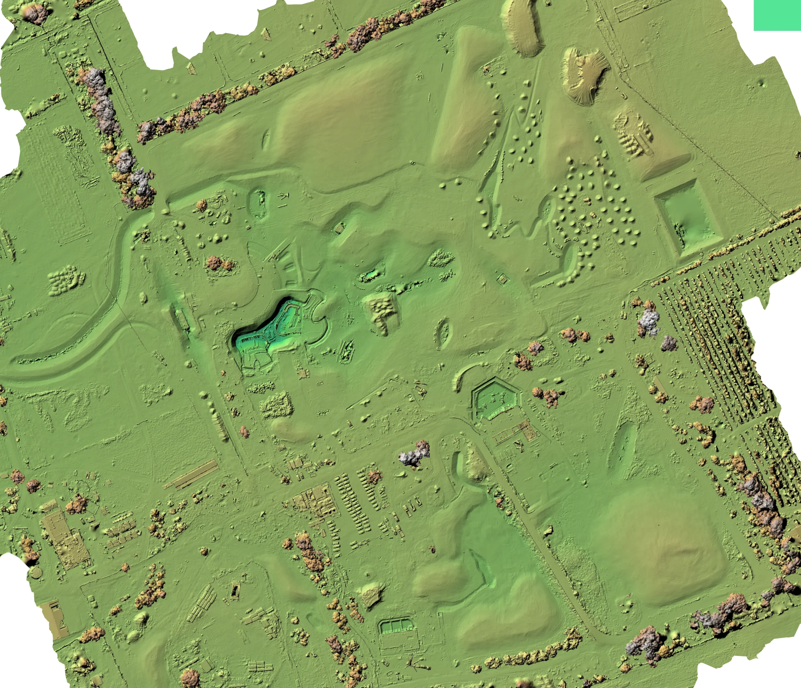
What the Survey Produces
- Bare-earth terrain models (DTM) with vegetation removed
- Elevation, slope, and aspect maps
- Drainage line and surface water flow mapping
- Depressions, ridges, and low-lying areas
- Potential waterlogging and ponding locations
- Catchment and flow-path mapping
- Erosion risk and gully mapping
- Terrain change measurement over time
- GIS-ready outputs for engineering and planning use
- PDF reports and scalable plans for practical on-farm use
Crop, Pasture & Vegetation Mapping
Multispectral aerial mapping captures plant health information that isn’t visible to the naked eye, revealing variability across crops, pastures, and native vegetation at a level of detail that ground observation alone can’t match across large areas.
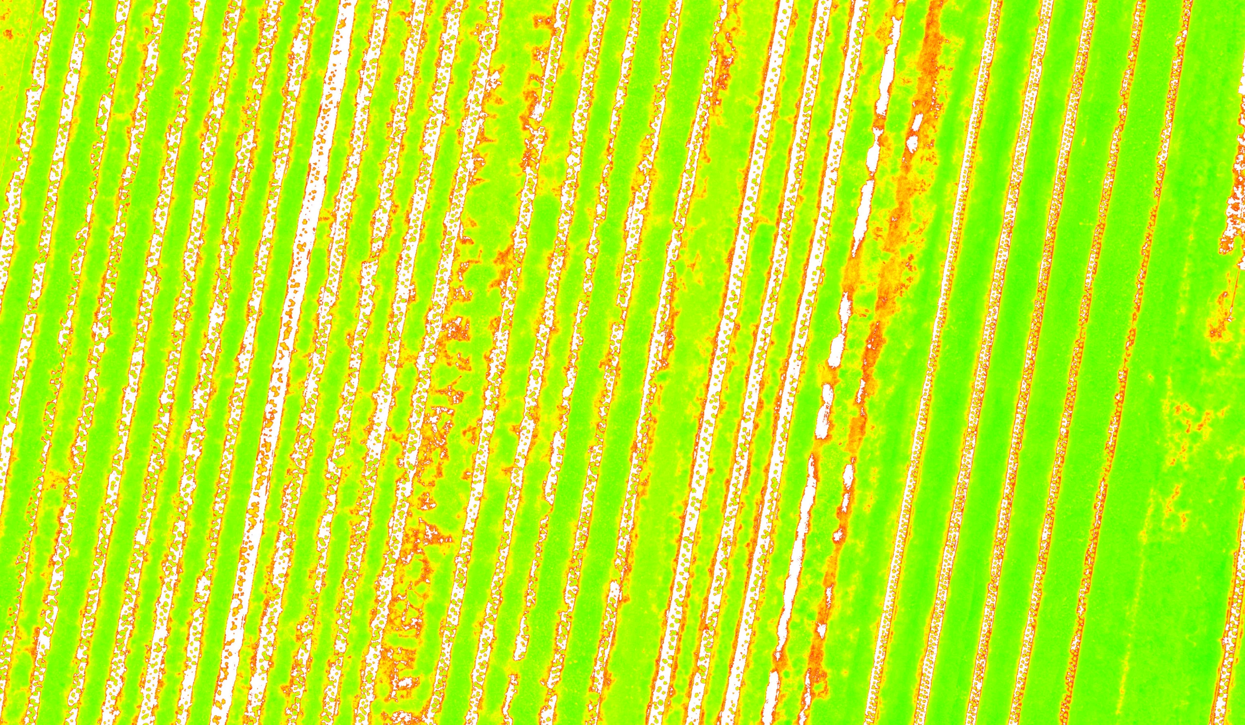
What Multispectral Mapping Produces
- High-resolution farm orthophotos
- RGB and multispectral imagery across the surveyed area
- NDVI, NDRE, GNDVI, and SAVI vegetation index maps
- Crop and pasture variability maps
- Vegetation stress pattern identification
- Uneven crop establishment mapping
- Priority areas flagged for field inspection
- Crop and pasture height estimates where survey conditions permit
- Vegetation encroachment along fences, tracks, drains, and waterways
- GIS layers, georeferenced imagery, and PDF maps
- Repeat surveys for seasonal comparison and trend monitoring
Important — What Multispectral Mapping Can and Can’t Tell You
Multispectral mapping identifies patterns in vegetation — areas of variability, stress, or inconsistency that may warrant closer investigation. It does not diagnose the specific cause of those patterns. Stress visible in a vegetation index map may relate to moisture, drainage, soil nutrients, weeds, pests, disease, or seasonal conditions — or a combination of these factors. Ground verification and specialist assessment by your agronomist or consultant are required to determine the cause and the appropriate response. Storm Spatial provides the spatial data. Your specialist determines what it means for your farm.
Using Satellite Imagery for Larger Areas
For initial assessment of large properties or broad landscape areas, freely available satellite multispectral imagery can provide a rapid overview of vegetation condition and variability at low cost. Where greater detail, higher resolution, or targeted investigation is required — over specific paddocks, problem areas, or selected zones — drone mapping provides substantially better data quality. Storm Spatial can advise on the most appropriate approach for your project scale and objectives.
Weed & Treatment Mapping
Weed & Treatment Mapping Outputs
- Weed distribution maps showing locations and extent of detected vegetation
- Potential weed hotspot identification for priority treatment
- Spot-spray maps for targeted ground or aerial application
- Variable-rate treatment zones for compatible spraying equipment
- Field boundaries, obstacles, and exclusion areas clearly mapped
- Spatial files suitable for compatible spraying systems where applicable
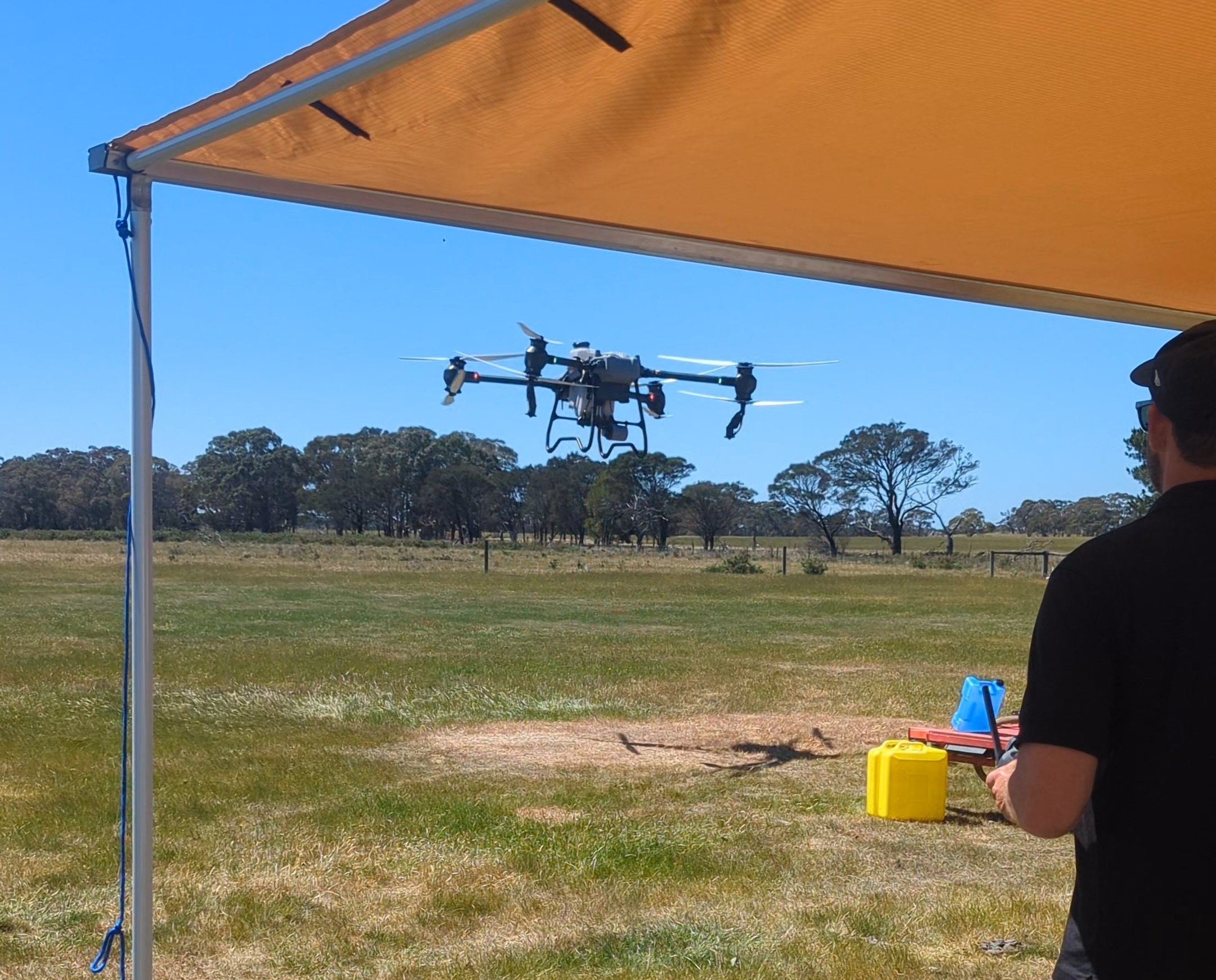
Important — Weed Mapping Results Depend on Conditions
The accuracy and usefulness of weed mapping outputs depends on a range of factors — including weed species, canopy cover, image quality, seasonal conditions, and site characteristics. Not all weed species or growth stages are reliably detectable from aerial imagery. Field verification is always recommended before treatment decisions are made. Storm Spatial provides the mapping data; treatment planning and agronomic decisions should involve your agronomist or weed management specialist.
What You Receive
- Georeferenced aerial imagery (GeoTiff)
- High-resolution RGB orthophotos
- Vegetation index maps (NDVI, NDRE, GNDVI, SAVI)
- Digital Terrain Models (DTM) and bare-earth elevation data
- Tree inventory tables and attribute data
- Weed distribution and treatment maps
- GIS layers (Shapefile, GeoPackage) for use in your GIS platform
- PDF maps and plans in standard paper sizes
- Drainage and waterflow analysis maps
- Data accessible via cloud-based viewing platform (no specialist software needed)
- Format delivered to suit your workflow — ask us if you have specific requirements
How It Works
1. Project Brief
Tell us about your site, your project requirements, and how you intend to use the data. We’ll advise on the most appropriate combination of aerial LiDAR, ground scanning, and GPS survey methods — and provide a clear, transparent quote. If your site requires flight approvals or airspace coordination, we handle that too.
2. Data Capture
Our team mobilises to site and captures aerial data across the surveyed area. Flight planning, airspace management, and data capture are all handled by Storm Spatial. Depending on your project, this may involve LiDAR scanning, multispectral imaging, or standard high-resolution photography — often in combination.
3. Processing & Delivery
Raw aerial data is processed into your required outputs — vegetation index maps, tree inventory data, terrain models, drainage analyses, or treatment maps. All deliverables are provided in your preferred formats, with access to our cloud-based viewing platform so your team and your consultants can explore the data directly.
Why Landowners & Consultants Choose Storm Spatial
Survey-Grade Accuracy
Aerial and Ground Combined
Practical, Usable Outputs
Geelong-Based, Victoria-Wide
Based in Geelong, Storm Spatial works across regional Victoria, greater Melbourne, and beyond. We’re accustomed to travelling to remote properties, agricultural corridors, and plantation sites across the state.
Frequently Asked Questions
What properties and land types is this mapping suitable for?
Agriculture and forestry mapping is suitable for most rural and semi-rural properties — from cropping and grazing farms to commercial plantations, shelterbelts, environmental reserves, and mixed land use properties. Storm Spatial works across property types of all sizes, from a few hundred hectares to large station or plantation scale. Contact us to discuss your property and we’ll advise on the most appropriate approach.
Can you map my whole property in one flight?
Can LiDAR see through dense tree canopy to map the ground?
Will NDVI mapping tell me why my crop is stressed?
How accurate is the tree data from a forestry LiDAR survey?
Can the weed mapping results be used directly in a sprayer?
Weed and treatment maps can be formatted as spatial files compatible with variable-rate and section-control spraying equipment where applicable. The suitability of the output for direct use in spraying equipment depends on your equipment’s software and input requirements. Storm Spatial can advise on output formats at the quoting stage. Treatment decisions — including herbicide selection, rates, and timing — remain the responsibility of your agronomist or weed management consultant.
What areas of Victoria do you service?
Storm Spatial is based in Geelong and works across Victoria, including the Surf Coast and Bellarine Peninsula, the Western Districts, Gippsland, the Wimmera, and regional Victoria more broadly. We also travel to properties in interstate areas for suitable project scales. Contact us to discuss your property location and we’ll confirm availability and mobilisation.
How do I get started?
Tell us about your property — location, approximate size, land type, and what you’re trying to achieve. We’ll come back to you with a recommended approach and a clear, no-obligation quote. We’re happy to have a preliminary conversation by phone before you commit to anything.